Top Qs
Timeline
Chat
Perspective
Local government areas of New South Wales
From Wikipedia, the free encyclopedia

Remove ads
This article is about local government areas in New South Wales. For the history and responsibilities of local government in New South Wales, see Local government in New South Wales.
This is a list of local government areas (LGAs) in New South Wales, sorted by region. As of September 2024[update] there were 128 local government areas in New South Wales,[1] there are 33 local government areas in Greater Sydney and 95 local government areas amongst 12 regions of Regional New South Wales. All councils are listed below in alphabetical order by region. There is also the Unincorporated Far West Region which is not part of any local government area, in the sparsely inhabited Far West, and Lord Howe Island, which is also unincorporated but self-governed by the Lord Howe Island Board.
Norfolk Island Regional Council is also subject to the state-level legislation of New South Wales.
Local elections are held in New South Wales every four years. The most recent elections were held in September 2024.
Remove ads
Maps
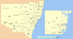 Map of LGAs in New South Wales
 Types and titles of LGAs in New South Wales
 LGA regions in New South Wales
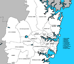 LGAs in Greater Sydney


Metropolitan LGAs
Greater Sydney
More information Date established, Area ...
| Local government area | Date established | Area[2] | Population[2] | Map | Council Seat | ||||
|---|---|---|---|---|---|---|---|---|---|
| Borough / District / Municipality / Shire | City | km2 | sq mi | Rank | 2018 | Rank | |||
| Metropolitan Sydney Local Government Areas | |||||||||
| Bayside Council | 13 January 1871 (1871-01-13) (as Rockdale Municipality) 29 March 1888 (1888-03-29) (as Borough of Botany) | 9 September 2016 (2016-09-09)[3] | 50 | 19 | 113 | 174,378 | 15 |  |
Rockdale Town Hall |
| Blacktown City Council | 6 March 1906 (Shire)[4] | 7 March 1979 (1979-03-07) | 240 | 93 | 103 | 366,534 | 2 |  |
Blacktown |
| Burwood, Municipality of | 27 March 1874[5] | n/a | 7.1 | 2.7 | 127 | 39,886 | 54 |  |
Burwood |
| Camden Council | 6 February 1889[6] | n/a | 201 | 78 | 104 | 94,159 | 27 |  |
Oran Park |
| Campbelltown, City of | 21 January 1882[7] | 4 May 1968 (1968-05-04) | 312 | 120 | 97 | 168,139 | 17 |  |
Campbelltown |
| Canada Bay, City of | 11 August 1883 (Municipal District of Concord)[8] 18 January 1890 (Borough of Drummoyne) | December 2000 (2000-12) | 20 | 7.7 | 120 | 95,159 | 26 |  |
Drummoyne |
| Canterbury-Bankstown, City of | 17 March 1879 (1879-03-17) (Municipal District of Canterbury) 7 September 1895 (1895-09-07) (Municipal District of Bankstown) | 12 May 2016 (2016-05-12)[9] | 110 | 42 | 108 | 373,931 | 1 |  |
Bankstown |
| Cumberland City Council | 9 July 1872 (1872-07-09) (as the Prospect and Sherwood Municipal District) | 12 May 2016 (2016-05-12)[10] | 72 | 28 | 112 | 236,893 | 7 |  |
Merrylands |
| Fairfield City Council | 11 December 1888 (1888-12-11) (as the Smithfield and Fairfield Municipal District) | 18 May 1979 (1979-05-18) | 102 | 39 | 109 | 210,612 | 11 |  |
Wakeley |
| Georges River Council | 22 December 1885 (1885-12-22) (as the Kogarah Municipality) 25 March 1887 (1887-03-25) (Municipal District of Hurstville) | 12 May 2016 (2016-05-12)[11] | 38 | 15 | 115 | 158,411 | 19 |  |
Hurstville |
| Hornsby Shire | 6 March 1906 (1906-03-06)[4] | n/a | 455 | 176 | 92 | 150,752 | 21 |  |
Hornsby |
| Hunter's Hill, Municipality of | 7 January 1861[12] | n/a | 5.7 | 2.2 | 128 | 14,909 | 76 |  |
Hunters Hill |
| Inner West Council | 1 November 1861 (1861-11-01) (Municipality of Marrickville) 28 December 1871 (1871-12-28) (Borough of Ashfield) 29 December 1871 (1871-12-29) (Municipal District of Leichhardt) | 12 May 2016 (2016-05-12)[13] | 35 | 14 | 117 | 198,024 | 14 |  |
Ashfield, Leichhardt, Petersham |
| Ku-ring-gai Council | 1906 (Shire)[4] 1928 (Municipality) | n/a | 85 | 33 | 110 | 126,046 | 23 |  |
Gordon |
| Lane Cove Council | 11 February 1895 (Borough of Lane Cove)[14] | n/a | 11 | 4.2 | 123 | 39,486 | 59 |  |
Lane Cove |
| Liverpool, City of | 27 June 1872 (1872-06-27) (Municipal District) | 9 November 1960 (1960-11-09) | 306 | 118 | 99 | 223,304 | 9 |  |
Liverpool |
| Mosman Council | 11 April 1893 (as Borough of Mosman)[15] | n/a | 8.7 | 3.4 | 126 | 30,877 | 59 |  |
Mosman |
| North Sydney Council | 31 July 1890 (as Borough of North Sydney)[16] | n/a | 11 | 4.2 | 123 | 74,172 | 34 |  |
North Sydney Council Chambers |
| Northern Beaches Council | 6 January 1877 (1877-01-06) (Manly Municipality) 7 March 1906 (1906-03-07) (as Warringah Shire)[4] 1 May 1992 (1992-05-01) (as Pittwater Municipality) | 12 May 2016 (2016-05-12)[17] | 254 | 98 | 102 | 271,278 | 4 |  |
Dee Why |
| Parramatta, City of | 27 November 1861 (1861-11-27) (Municipality) | 12 May 2016 (2016-05-12)[18] | 84 | 32 | 111 | 251,311 | 5 |  |
Parramatta Town Hall |
| Penrith, City of | 12 May 1871 (1871-05-12) (Municipality)[19] | 21 October 1959 (1959-10-21) | 405 | 156 | 93 | 209,210 | 12 |  |
Penrith |
| Randwick, City of | 23 February 1859[20] | 1 July 1990[21] | 36 | 14 | 116 | 154,265 | 20 |  |
Randwick Town Hall |
| Ryde, City of | 12 November 1870 (1870-11-12) (Municipal district) | 1 January 1992 (1992-01-01) | 41 | 16 | 114 | 127,446 | 22 |  |
Ryde |
| Strathfield, Municipality of | 2 June 1885 (1885-06-02) | n/a | 14 | 5.4 | 121 | 45,143 | 49 |  |
Strathfield |
| Sutherland Shire | 6 March 1906 (1906-03-06)[4] | n/a | 334 | 129 | 96 | 229,213 | 8 |  |
Sutherland |
| Sydney, City of | n/a | 20 July 1842 (1842-07-20)[22] | 27 | 10 | 118 | 240,229 | 6 |  |
Sydney Town Hall |
| The Hills Shire | 6 March 1906 (1906-03-06)[4] (as Baulkham Hills Shire) | n/a | 386 | 149 | 95 | 172,473 | 16 |  |
Norwest |
| Waverley Council | 16 June 1859 (1859-06-16)[23] | n/a | 9.4 | 3.6 | 125 | 74,114 | 35 |  |
Bondi Junction |
| Willoughby, City of | 23 October 1865[24] | 17 November 1989[25] | 22 | 8.5 | 119 | 80,339 | 31 |  |
Chatswood |
| Woollahra, Municipality of | 20 April 1860 (1860-04-20)[26] | n/a | 12 | 4.6 | 122 | 58,964 | 43 |  |
Double Bay |
| Outer Metropolitan Sydney Local Government Areas | |||||||||
| Blue Mountains, City of | 4 January 1889 (1889-01-04) (as the Municipality of Katoomba)[27] | 1 October 1947 (1947-10-01) | 1,431 | 553 | 82 | 79,260 | 32 |  |
Katoomba |
| Hawkesbury, City of | 1843 (as Windsor District Council) | 1 January 1981[28] | 2,775 | 1,071 | 69 | 67,083 | 38 |  |
Windsor |
| Wollondilly Shire | 6 March 1906[4] | n/a | 2,555 | 986 | 71 | 52,230 | 46 |  |
Picton |
Close
Remove ads
Regional LGAs
Summarize
Perspective
Northern
Central Coast
More information Date established, Area ...
| Local government area | Date established | Area[2] | Population[2] | Map | Council Seat | ||||
|---|---|---|---|---|---|---|---|---|---|
| Municipality / Shire | City | km2 | mi2 | Rank | (2018) | Rank | |||
| Central Coast Council | 11 November 1886 (1886-11-11) (as Borough of Gosford) 1 January 1947 (1947-01-01) (as Wyong Shire)[29] | 12 May 2016 (2016-05-12)[30] | 1,681 | 649 | 78 | 342,047 | 3 |  |
Gosford, Wyong |
Close
Hunter
More information Date established, Area ...
| Local government area | Date established | Area[2] | Population[2] | Map | Council Seat | ||||
|---|---|---|---|---|---|---|---|---|---|
| Municipality / Shire | City | km2 | mi2 | Rank | (2018) | Rank | |||
| Greater Newcastle Local Government Areas[31] | |||||||||
| Cessnock, City of | 7 March 1906 (Shire)[32] | n/a | 1,965 | 759 | 76 | 59,101 | 42 |  |
Cessnock |
| Lake Macquarie, City of | 7 March 1906 (1906-03-07) (Shire) 1 April 1977 (1977-04-01) (Municipality) | 7 September 1984 (1984-09-07) | 649 | 251 | 89 | 204,914 | 13 |  |
Speers Point |
| Maitland, City of | 12 March 1862 (as Municipality of East Maitland) | 7 December 1945[33] | 392 | 151 | 94 | 83,203 | 29 |  |
Maitland |
| Newcastle, City of | 8 June 1859 (Municipality)[34] | 26 January 1848[35] | 187 | 72 | 105 | 164,104 | 18 |  |
Newcastle |
| Port Stephens Council | 7 March 1906 (Shire)[4] | n/a | 858 | 331 | 87 | 72,695 | 36 |  |
Raymond Terrace |
| Other Hunter Local Government Areas | |||||||||
| Dungog Shire | 16 May 1893[36] | n/a | 2,250 | 870 | 73 | 9,346 | 93 |  |
Dungog |
| Muswellbrook Shire | 13 April 1870 (Municipal District of Musclebrook)[37] | n/a | 3,405 | 1,315 | 61 | 16,383 | 75 |  |
Muswellbrook |
| Singleton Council | 2 February 1866 (Municipality)[38] | n/a | 4,893 | 1,889 | 46 | 23,422 | 65 |  |
Singleton |
| Upper Hunter Shire | 26 May 2004 (2004-05-26)[39] | n/a | 8,096 | 3,126 | 29 | 14,220 | 79 |  |
Scone |
Close
Mid North Coast
More information Date established, Area ...
| Local government area | Date established | Area[2] | Population[2] | Map | Council Seat | ||||
|---|---|---|---|---|---|---|---|---|---|
| Municipality / Shire | City | km2 | mi2 | Rank | (2018) | Rank | |||
| Bellingen Shire | 30 November 1956[40] | n/a | 1,600 | 620 | 79 | 12,963 | 83 |  |
Bellingen |
| Coffs Harbour, City of | 30 November 1956 (Shire) | 1 May 1987[40][41] | 1,174 | 453 | 85 | 76,551 | 33 |  |
Coffs Harbour |
| Kempsey Shire | 11 June 1886 (Borough)[42] | n/a | 3,376 | 1,303 | 62 | 29,665 | 62 |  |
Kempsey |
| MidCoast Council | 7 March 1906 (1906-03-07) (as Gloucester Shire) 7 March 1906 (1906-03-07) (Municipality of Great Lakes) 1 January 1981 (1981-01-01) (Borough of Taree)[43] | 12 May 2016 (2016-05-12) | 10,054 | 3,882 | 19 | 93,288 | 28 |  |
Gloucester, Forster, Taree |
| Nambucca Valley Council | 15 December 1915[44] | n/a | 1,491 | 576 | 81 | 19,773 | 70 |  |
Macksville |
| Port Macquarie-Hastings Council | 13 July 2005 (2005-07-13) 1 January 1881 (1881-01-01) (Municipality of Hastings)[45] | n/a | 3,682 | 1,422 | 56 | 83,131 | 30 |  |
Port Macquarie |
| Lord Howe Island | 1913 (Board of Control), 1954 (Board)[46] | n/a | 15 | 5.8 | n/a | 382[47] | n/a | N/A | |
Close
New England
More information Date established, Area ...
| Local government area | Date established | Area[2] | Population[2] | Map | Council Seat | |||
|---|---|---|---|---|---|---|---|---|
| km2 | mi2 | Rank | (2018) | Rank | ||||
| Armidale Regional Council | 12 May 2016 (2016-05-12) | 8,621 | 3,329 | 26 | 30,707 | 61 |  |
Armidale |
| Glen Innes Severn Council | 15 September 2004 17 June 1872 (Municipal District of Glen Innes)[48] | 5,480 | 2,120 | 41 | 8,908 | 95 |  |
Glen Innes |
| Gunnedah Shire | 19 September 1885 (Municipal District)[49] | 4,987 | 1,925 | 45 | 12,661 | 85 |  |
Gunnedah |
| Gwydir Shire | 17 March 2004 (2004-03-17)[50] | 9,260 | 3,580 | 22 | 5,349 | 112 |  |
Bingara |
| Inverell Shire | 5 March 1872 (Municipal District)[51] | 8,597 | 3,319 | 27 | 16,844 | 74 |  |
Inverell |
| Liverpool Plains Shire | 17 March 2004[50] | 5,082 | 1,962 | 44 | 7,893 | 99 |  |
Quirindi |
| Moree Plains Shire | 5 December 1890 (Municipal District of Moree)[52] | 17,907 | 6,914 | 9 | 13,350 | 81 |  |
Moree |
| Narrabri Shire | 28 September 1895 (Municipal District of West Narrabri)[53] | 13,015 | 5,025 | 13 | 13,231 | 81 |  |
Narrabri |
| Tamworth Regional Council | 17 March 2004 (as Peel Regional)[50] | 9,884 | 3,816 | 21 | 59,663 | 40 |  |
Tamworth |
| Tenterfield Shire | 23 November 1871 (Municipal District)[54] | 7,323 | 2,827 | 31 | 6,638 | 102 |  |
Tenterfield |
| Uralla Shire | 24 April 1882 (Municipal District)[55] | 3,227 | 1,246 | 63 | 6,062 | 107 |  |
Uralla |
| Walcha Shire | 1 June 1955 (1955-06-01)[56] | 6,261 | 2,417 | 36 | 3,132 | 120 |  |
Walcha |
Close
Northern Rivers
More information Date established, Area ...
| Local government area | Date established | Area[2] | Population[2] | Map | Council Seat | ||||
|---|---|---|---|---|---|---|---|---|---|
| Municipality / Shire | City | km2 | mi2 | Rank | (2018) | Rank | |||
| Ballina Shire | 1 January 1977 (1977-01-01) | n/a | 485 | 187 | 91 | 44,208 | 50 |  |
Ballina |
| Byron Shire | 6 March 1906 (1906-03-06)[4] | n/a | 566 | 219 | 90 | 34,574 | 57 |  |
Mullumbimby |
| Clarence Valley Council | 25 February 2004[57] | n/a | 10,429 | 4,027 | 18 | 51,647 | 47 |  |
Grafton, Maclean |
| Kyogle Council | 6 March 1906 (Shire)[4] | n/a | 3,584 | 1,384 | 58 | 8,870 | 96 |  |
Kyogle |
| Lismore, City of | 1879 (Municipality)[58] | 9 September 1946 (1946-09-09) | 1,288 | 497 | 84 | 43,843 | 51 |  |
Goonellabah |
| Richmond Valley Council | February 2000 (2000-02) | n/a | 3,047 | 1,176 | 65 | 23,399 | 66 |  |
Casino |
| Tweed Shire | 1 January 1947 (1947-01-01) | n/a | 1,308 | 505 | 83 | 96,108 | 25 |  |
Murwillumbah |
Close
Southern
Illawarra
More information Date established, Area ...
| Local government area | Date established | Area[2] | Population[2] | Map | Council Seat | ||||
|---|---|---|---|---|---|---|---|---|---|
| Municipality / Shire | City | km2 | mi2 | Rank | (2018) | Rank | |||
| Greater Wollongong Local Government Areas | |||||||||
| Kiama, Municipality of | 11 August 1859 (1859-08-11) (Municipality) | n/a | 258 | 100 | 101 | 23,006 | 67 |  |
Kiama |
| Shellharbour, City of | 4 June 1859 (1859-06-04) (Municipality) | May 1996 | 147 | 57 | 107 | 72,240 | 37 |  |
Shellharbour City Centre |
| Wollongong, City of | 24 August 1843 (1843-08-24) (as Illawarra District Council) | 11 September 1942 (1942-09-11) | 684 | 264 | 88 | 216,071 | 10 |  |
Wollongong |
| Other Illawarra Local Government Areas | |||||||||
| Shoalhaven, City of | 1 July 1948 (1948-07-01) (Shire) | 13 July 1979 (1979-07-13)[59] | 4,567 | 1,763 | 50 | 104,371 | 24 |  |
Nowra |
Close
South Coast
More information Date established, Area ...
| Local government area | Date established | Area[2] | Population[2] | Map | Council Seat | |||
|---|---|---|---|---|---|---|---|---|
| km2 | mi2 | Rank | (2018) | Rank | ||||
| Bega Valley Shire | 1981[60] | 6,279 | 2,424 | 35 | 34,348 | 58 |  |
Bega |
| Eurobodalla Shire | 17 November 1913 (1913-11-17) | 3,428 | 1,324 | 59 | 38,288 | 56 |  |
Moruya |
Close
Southern Highlands
More information Date established, Area ...
| Local government area | Date established | Area[2] | Population[2] | Map | Council Seat | ||||
|---|---|---|---|---|---|---|---|---|---|
| Municipality / Shire | City | km2 | mi2 | Rank | (2018) | Rank | |||
| Wingecarribee Shire | 1 January 1981 (1981-01-01) | n/a | 2,689 | 1,038 | 70 | 50,493 | 48 |  |
Moss Vale |
Close
Southern Tablelands
More information Date established, Area ...
| Local government area | Date established | Area[2] | Population[2] | Map | Council Seat | ||||
|---|---|---|---|---|---|---|---|---|---|
| Municipality / Shire | City | km2 | mi2 | Rank | (2018) | Rank | |||
| Goulburn Mulwaree Council | 11 February 2004 (2004-02-11) | 3,220 | 1,240 | 64 | 30,852 | 60 |  |
Goulburn | |
| Hilltops Council | 12 May 2016 (2016-05-12)[61] | 7,141 | 2,757 | 32 | 18,782 | 71 |  |
Boorowa, | |
| Queanbeyan–Palerang Regional Council | 12 May 2016 (2016-05-12)[62] | 5,319 | 2,054 | 42 | 59,959 | 41 |  |
Queanbeyan | |
| Snowy Monaro Regional Council | 12 May 2016 (2016-05-12)[63] | 15,164 | 5,855 | 10 | 20,733 | 69 |  |
Cooma | |
| Upper Lachlan Shire | 17 March 2004[50] | 7,127 | 2,752 | 33 | 7,961 | 98 |  |
Crookwell | |
| Yass Valley Council | 1 January 1980 (1980-01-01) (Shire) 11 February 2004 (2004-02-11) (Municipality) | 3,995 | 1,542 | 53 | 16,953 | 73 |  |
Yass | |
Close
Western
Central West
More information Date established, Area ...
| Local government area | Date established | Area[2] | Population[2] | Map | Council Seat | ||||
|---|---|---|---|---|---|---|---|---|---|
| Municipality / Shire | City | km2 | mi2 | Rank | (2018) | Rank | |||
| Bathurst Regional Council | 26 May 2004 (2004-05-26)[39] | n/a | 3,818 | 1,474 | 55 | 43,206 | 52 |  |
Bathurst |
| Blayney Shire | 1 November 1882[64] | n/a | 1,525 | 589 | 80 | 7,342 | 100 |  |
Blayney |
| Cabonne Shire | 1 October 1977[65] | n/a | 6,022 | 2,325 | 37 | 13,680 | 80 |  |
Molong |
| Cowra Shire | 1980 (1980) | n/a | 2,829 | 1,092 | 67 | 12,767 | 84 |  |
Cowra |
| Forbes Shire | 4 June 1870[66] (as Municipal District) | n/a | 4,710 | 1,820 | 49 | 9,910 | 91 |  |
Forbes |
| Lachlan Shire | 6 March 1906[4] | n/a | 14,964 | 5,778 | 11 | 6,151 | 106 |  |
Condobolin |
| Lithgow, City of | 4 June 1889 (Municipality)[67] | 21 December 1945[68] | 4,512 | 1,742 | 51 | 21,636 | 68 |  |
Lithgow |
| Mid-Western Regional Council | 26 May 2004 (2004-05-26)[39] | n/a | 8,752 | 3,379 | 25 | 25,086 | 64 |  |
Mudgee |
| Oberon Shire | 6 March 1906[4] | n/a | 3,625 | 1,400 | 57 | 5,408 | 111 |  |
Oberon |
| Orange, City of | 9 January 1860 (Municipality)[69] | 10 July 1946 | 284 | 110 | 100 | 42,056 | 53 |  |
Orange |
| Parkes Shire | 1 March 1883 (as Municipal District)[70] | n/a | 5,958 | 2,300 | 38 | 14,894 | 77 |  |
Parkes |
| Weddin Shire | 6 March 1906[4] | n/a | 3,415 | 1,319 | 60 | 3,636 | 118 |  |
Grenfell |
Close
Far West
More information Date established, Area ...
| Local government area | Date established | Area[2] | Population[2] | Map | Council Seat | ||||
|---|---|---|---|---|---|---|---|---|---|
| Municipality / Shire | City | km2 | mi2 | Rank | (2018) | Rank | |||
| Broken Hill, City of | n/a | 24 September 1888[71] | 170 | 66 | 106 | 17,734 | 72 |  |
Council Chambers, Broken Hill |
| Central Darling Shire | 20 March 1959[72] 6 February 1883 (as Municipal District of Wilcannia)[73] | n/a | 53,492 | 20,653 | 1 | 1,837 | 127 |  |
Wilcannia |
| Unincorporated Far West | n/a | 93,199 | 35,984 | 674 |  |
N/A | |||
Close
Murray
More information Date established, Area ...
| Local government area | Date established | Area[2] | Population[2] | Map | Council Seat | ||||
|---|---|---|---|---|---|---|---|---|---|
| Municipality / Shire | City | km2 | mi2 | Rank | (2018) | Rank | |||
| Albury, City of | 4 June 1859 (as Municipality)[74] | 1946[75] | 306 | 118 | 98 | 53,767 | 44 |  |
Albury |
| Balranald Shire | 27 September 1882[76] | n/a | 21,691 | 8,375 | 6 | 2,340 | 126 |  |
Balranald |
| Berrigan Shire | 6 March 1906[4] | n/a | 2,066 | 798 | 74 | 8,707 | 97 |  |
Berrigan |
| Edward River Council | 1907 (1907) (as Conargo Shire) 16 December 1868 (1868-12-16) (as Deniliquin Council)[77] | 12 May 2016 (2016-05-12) | 8,884 | 3,430 | 24 | 8,995 | 94 |  |
Deniliquin |
| Federation Council | 1955 (1955) (as Corowa Shire) 1906 (1906) (as Urana Shire)[78] | 12 May 2016 (2016-05-12) | 5,685 | 2,195 | 40 | 12,462 | 86 |  |
Corowa |
| Greater Hume Shire | 26 May 2004[39] | n/a | 5,750 | 2,220 | 39 | 10,686 | 90 |  |
Holbrook |
| Murray River Council | 12 May 2016 (2016-05-12)[79] | n/a | 11,864 | 4,581 | 15 | 12,118 | 87 |  |
Moama |
| Wentworth Shire | 23 January 1879 (1879-01-23) (Municipality)[80] and (Shire) | n/a | 26,256 | 10,137 | 4 | 7,042 | 101 |  |
Wentworth |
Close
Orana
More information Date established, Area ...
| Local government area | Date established | Area[2] | Population[2] | Map | Council Seat | |||
|---|---|---|---|---|---|---|---|---|
| km2 | mi2 | Rank | (2018) | Rank | ||||
| Bogan Shire | 17 February 1891 (Municipality) 7 May 1906 (Shire)[4] | 14,600 | 5,600 | 12 | 2,621 | 125 |  |
Nyngan |
| Bourke Shire | 4 July 1878[81] | 41,600 | 16,100 | 3 | 2,630 | 124 |  |
Bourke |
| Brewarrina Shire | 15 January 1901[82] | 19,164 | 7,399 | 7 | 1,655 | 128 |  |
Brewarrina |
| Cobar Shire | 18 March 1884[83] | 45,579 | 17,598 | 2 | 4,722 | 113 |  |
Cobar |
| Coonamble Shire | 3 May 1880[84] | 9,916 | 3,829 | 20 | 4,014 | 116 |  |
Coonamble |
| Dubbo Regional Council | 12 May 2016 (2016-05-12)[85] | 7,535 | 2,909 | 30 | 53,240 | 45 |  |
Dubbo |
| Gilgandra Shire | 6 March 1906[4] | 4,832 | 1,866 | 47 | 4,226 | 115 |  |
Gilgandra |
| Narromine Shire | 23 April 1898[86] | 5,262 | 2,032 | 43 | 6,567 | 104 |  |
Narromine |
| Walgett Shire | 6 March 1906[4] | 22,308 | 8,613 | 5 | 6,051 | 108 |  |
Walgett |
| Warren Shire | 24 April 1895[87] | 10,754 | 4,152 | 17 | 2,745 | 123 |  |
Warren |
| Warrumbungle Shire | 25 August 2004[88] | 12,372 | 4,777 | 14 | 9,399 | 92 |  |
Coonabarabran |
Close
Riverina
More information Date established, Area ...
| Local government area | Date established | Area[2] | Population[2] | Map | Council Seat | ||||
|---|---|---|---|---|---|---|---|---|---|
| Municipality / Shire | City | km2 | mi2 | Rank | (2018) | Rank | |||
| Bland Shire | 6 March 1906[4] | n/a | 8,558 | 3,304 | 28 | 5,985 | 109 |  |
West Wyalong |
| Carrathool Shire | 27 October 1943[89] | n/a | 18,935 | 7,311 | 8 | 2,802 | 122 |  |
Goolgowi |
| Coolamon Shire | 6 March 1906[4] | n/a | 2,431 | 939 | 73 | 4,368 | 114 |  |
Coolamon |
| Cootamundra-Gundagai Regional Council | 1 April 1975 (1975-04-01) (as Cootamundra Shire) 1 January 1924 (1924-01-01) (as Gundagai Shire)[90] | 12 May 2016 (2016-05-12) | 3,981 | 1,537 | 54 | 11,260 | 89 |  |
Cootamundra, |
| Griffith, City of | 6 January 1928 (1928-01-06) | 1 January 1982 (1982-01-01) | 1,639 | 633 | 78 | 26,882 | 63 |  |
Griffith |
| Hay Shire | 1 January 1965[91]
10 June 1872 (as Municipality) |
n/a | 11,326 | 4,373 | 16 | 2,979 | 121 |  |
Hay |
| Junee Shire | 26 July 1886 (Borough)[92] | n/a | 2,030 | 780 | 75 | 6,631 | 103 |  |
Junee |
| Leeton Shire | 20 December 1927
(Willimbong Shire)[93] |
n/a | 1,167 | 451 | 86 | 11,438 | 88 |  |
Leeton |
| Lockhart Shire | 6 March 1906[4] | n/a | 2,896 | 1,118 | 66 | 3,295 | 119 |  |
Lockhart |
| Murrumbidgee Council | 12 May 2016 (2016-05-12)[94] | n/a | 6,881 | 2,657 | 34 | 3,961 | 117 |  |
Darlington Point, Jerilderie |
| Narrandera Shire | 1 January 1960 (1960-01-01) | n/a | 4,116 | 1,589 | 52 | 5,931 | 110 |  |
Narrandera |
| Snowy Valleys Council | 12 May 2016 (2016-05-12)[95] | n/a | 8,959 | 3,459 | 23 | 14,532 | 78 |  |
Tumut, Tumbarumba |
| Temora Shire | 1 January 1981 | n/a | 2,802 | 1,082 | 68 | 6,274 | 105 |  |
Temora |
| Wagga Wagga, City of | 15 March 1870 (Borough)[96] | 1 January 1981 (1981-01-01) | 4,825 | 1,863 | 48 | 64,820 | 39 |  |
Wagga Wagga |
Close
Remove ads
Lord Mayoralties
There are four councils in NSW whose office of Mayor has been elevated to Lord Mayor. The process requires that the Premier of the day write to the reigning monarch to request the ascent.
More information Year of Royal Assent, Incumbent ...
| Local Government Area | Year of Royal Assent | Incumbent | Term Start | Map |
|---|---|---|---|---|
| City of Sydney | 1930 | Clover Moore | 27 March 2004 | |
| City of Newcastle | 1948 | Nuatali Nelmes | 15 November 2014 | |
| City of Wollongong | 10 April 1970 | Tania Brown[97] | 14 September 2024 |  |
| City of Parramatta | 12 December 1988 | Pierre Esber | 25 September 2023 | |
Close
Remove ads
Former local government areas in New South Wales
For a more comprehensive list, see List of former local government areas in New South Wales.
See also
References
External links
Wikiwand - on
Seamless Wikipedia browsing. On steroids.
Remove ads
Remove ads